
The MRPP – Mixed Reality Preparedness Platform
The Mixed Reality Preparedness Platform is a tool that combines many types of technologies to integrate how responders perceive information on the ground and how they direct their resources.
Hover over the interactive infographic below to find out more
How does the MRPP work?
MRPP
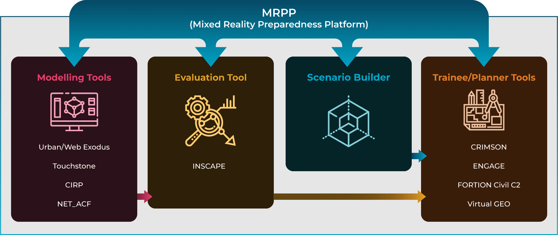
MRPP (Mixed Reality Preparedness Platform)
- A user-friendly IT training platform for collaborative response planning
- Training modules for emergency service personnel and first responders where they can test preparedness planning
- Allows emergency services to communicate and collaborate more effectively on both an inter-agency and cross-border basis in real-time during crisis situations as well as simulated training environments
Who uses it?
- Civil protection agencies, first responders and emergency service personnel
- Trained volunteers working with NGOs and civil defence organisations
- Governmental agencies and local authorities for emergency response planning
- SMEs and industry involved in disaster management, resilience and preparedness
Modelling Tools
The Modelling Tools are injected into the scenario for planning/training purposes
- Urban/Web Exodus – Simulates evacuation scenarios
- Touchstone – Models hazard impact and infrastructure damage
- CIRP – Climate change risk assessment simulation and analysis toolbox
- NET_ACF – Models smoke plumes and forest fires propagation
Modelling Tools feed directly into the Scenario Builder which develops the training scenarios
Evaluation Tools
The Evaluation Tool creates the view of the trainer/evaluator of the scenario
INSCAPE – Tool for trainer which creates, edits and publishes the scenario (venue for the disaster, objects, number of people involved etc.)
Scenario Builder
The Scenario Builder develops the training scenarios
Trainee/Planner Tools
The Trainee/Planner Tools are what the participants use/see when executing a scenario in real-time during a disaster or in a simulated training environment
- Virtual GEO – Software for merging, visualising and analysing 2D and 3D geospatial information using ground and aerial sensors (drones). Enhances situational awareness by creating a map of the affected area
- ENGAGE – Command centre image for incident and resource management. Real-time view of scenario showing communications and inputs between the responding agencies
- FORTION Civil C2 – Presents a Common Operational Picture (COP) allowing all participants to communicate with each other and view inputs by all responding agencies. Tracking available assets and their positions (vehicles etc.)
- CRIMSON – Assists in chain of command, scenario control tool for overseeing planning and training exercises